Road closure information

The forest road to Akadake-Ginsendai and Kogen Onsen has been reopened.
The forest road to Aizankei remains closed.
*The road to Aizankei was reopened at 10:00 a.m.
August 6, 2014

Road closure announcement

The forest roads linking Ginsendai, Kogen Onsen, and Aizankei have been closed due to rain.
Other forest roads may also be closed depending on weather conditions.
If you are planning to enter the mountains via a forest road tomorrow or in the days following, please contact the organization in charge before setting out.
Information on the two roads mentioned above can also be accessed via the link provided under “road and pass information” on the Visitor Center website’s main page.
August 5, 2014

A Visitor Center course

Yesterday, the Visitor Center held a course and marshland walk titled “Kogen Onsen-numa Route.”
The area of the walk is popular with climbers during the fall foliage season. The cluster of ponds was formed when landslide material from Takanegahara became deposited there and then subsided over many, many years. Water filled the resulting depressions to form more than 100 ponds.
The numerous ponds of various sizes seemed to form a shape resembling an open folding fan (ogi in Japanese) when they were first discovered, and therefore this location was called “Ogigahara.”
The area was discovered in 1916. The forest road there was built as part of work to deal with trees knocked over by the “Toya-maru Typhoon” of 1954 and later extended to the hot spring area. The Daisetsu Kogen Onsen Hotel was built in 1963. The discovery of the Kogen-numa area was noted on a surveyed topographical map in 1926, and the walking course around the ponds was completed in 1961.
Over 150 species of plant can be seen in the area, among them Hypericum yojiroanum, which is a plant specific to the Daisetsu area, and Viola epipsiloides, which is a plant specific to Hokkaido.
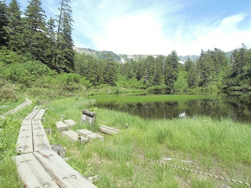
Photo: Near Midori-numa Aug. 3

Around the Akaishi River and Hokkaisawa Stream

The Akaishi River is a little high today, enough to splash on to hiking boots.
The rocks are somewhat slippery, so it is best to take care when crossing and to have the proper equipment. It is also a good idea to check if rain fell the previous day before setting out.
Communities of Primula cuneifolia var. cuneifolia and Phyllodoce aleutica are forming nearby.
The Diapensia lapponica subsp. obovata, Loiseleuria procumbens, and other plants are also flowering where the snow has melted.
In the area of the Hokkaisawa Stream, it is possible to spot small communities of Sieversia pentapetala and Phyllodoce caerulea.
Photos: Areas around the Akaishi River and Hokkaisawa Stream Aug. 1

Around Kumonotaira

Although the Sieversia pentapetala and Phyllodoce caerulea are still forming communities in the distance, the Sieversia pentapetala have become cottony in most areas.
Mixed in among them are Potentilla matsumurae, Primula cuneifolia var. cuneifolia, Solidago virgaurea subsp. leiocarpa, and Gentiana nipponica.
Flowering seems to be ending for the Therorhodion camtschaticum on the peak and Bryanthus gmelinii near Ishimuro. The scene appears to be being set for autumn.
Photo: A community of cottony Sieversia pentapetala at Kumonotaira Aug. 1