The Onuma campsite is unusable.

The rains that have fallen for the past few days have filled Onuma beyond its capacity and completely flooded the campsite on its bank. Visitors should be aware that there are absolutely no spaces on which a tent can be pitched.
Photo: Onuma campsite Aug. 14

The forest road to Numanohara is open.

It was feared that the forest road to Numanohara (Sounkyo Honyru Rindo) would be damaged by rain from the passing low-pressure system that had been Typhoon No. 11. However, no serious damage occurred and the road is passable.
The continuing rain of the past few days has created scattered muddy areas on the trail. The photo shows where the trail crosses the Nishikisawa Stream. Although the water is somewhat high, the stream can be crossed without wet shoes if an effort is made to find a good route.
Photo: The Nishikisawa Stream crossing Aug. 14

The Sasa kurilensis corridor has been cut back.

Even though I’m an experienced climber, I had heretofore given up on taking the trail from the Numanohara junction to Mt. Ishikari via the Sasa kurilensis corridor because the corridor had grown into a jungle. However, the plants have been cut back nicely and the “jungle” is now gone.
Photo: The Numanohara junction Aug. 14

Mt. Aka course report

On the Mt. Aka course, the Gentiana algida f. igarashii and Bryanthus gmelinii are blooming in a few places near the peak; however, almost no other conspicuous flowers are seen. At Daiyon Sekkei, Sieversia pentapetala, Phyllodoce aleutica, Arnica unalaschcensis var. unalaschcensis, Veronica stelleri var. longistyla, and Gentiana nipponica can be seen, although it must be said that the flowering season has nearly ended along most of the course.
The only snowy gorge on the Mt. Aka course trail is a roughly 40-meter area that remains at Daini Kaen.
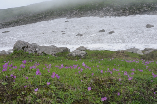
Photo: Primula cuneifolia var. cuneifolia at Daini Kaen, Mt. Aka Aug. 9

Mt. Aka – Mt. Kurodake course trail report

There are several places on the Mt. Aka – Mt. Kurodake course trail where large gullies and gouges were formed by the recent heavy rain.
While the damage is not enough to block passage, climbers should be cautious when going by them.
There are particularly large gullies in two locations; one is between the Mt. Koizumi junction and Mt. Hakuun junction, and the other is between the Mt. Hokkaidake peak and the bench midway up Mt. Hokkaidake.
Photo: A large gully above the bench on Mt. Hokkaidake Aug. 9